|
LIPARI - SALINA - VULCANO - STROMBOLI -
FILICUDI - ALICUDI - PANAREA
Province Messina
Information Lipari, C so Vitt Emanuele, 239
HOW TO GET TO EOLIAN ISLES:
Air: Reggio Calabria - Catania - Palermo
RAILWAY: MILAZZO STATION
Ferry-boat: several services daily from Milazzo - 3 times per week from
Napoli
Hydrofoil: several services daily from Milazzo - daily from Messina and
Reggio Calabria
Summer only,
Palermo - Cefalu - S Agata Militello - Capo d'Orlando -
Maratea - Vibo Valentia - Napoli
Motorway: A-20 turn off for Milazzo -
Isole Eolie
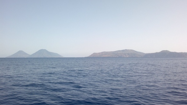
THE ARC OF FIRE
Scientifically the archipelago is defined
as a "volcanic arc" Geology explains the origin of the
islands as a result of the "continental drift" or movement of the earth's crust The African continental shelf is in
constant movement towards Europe The resulting collision has
created a volcanic area with ruptures in the earth's crust
with consequent eruptions of magma The "Eolian arc" extends
for more than 140 kilometres but the area of geological
instability caused by the collision of Africa with Europe is
very much larger It includes Sicily, Calabria, Campania
together with Greece and the Aegean islands The complex of
the seven Eolian islands, covering an area of 1600 square
kilometres, originated from a great plain at the bottom of
the Tyrrhenian sea Emitions of lava from depths of up to
3600 metres resulted in the formation of our islands
together with Ustica and a series of submarine volcanoes
named Magnani, Vavilov, Marsili and Palmuro as well as two
that are unnamed The present shape of the Eolian islands is
the result of volcanic activity over a period of 360,000
years The oldest islands are Panarea Fihcudi,
Strombolicchio, while the most recent is Stromboh Vulcanello
is the youngest volcano The Museum of Vulcanology at the
Castle in Lipari is well worth visiting
HISTORICAL NOTES
4000 - 2500 BC. First evidence of Sicilian
migration in Lipari (Castellaro Vec-chio) Manufacture and
commerce of obsidian highly developed until the introduction
of metals
7600 - 7250 BC. During the Bronze age the
Eolians prosper by means of maritime commerce in an area
extending from Mycenae to the British isles from where tin
was imported Villages flourished in Capo Graziano
(Filicudi), Castello (Li-pari), Serro dei Cianfi (Salma),
Capo Milazzese (Panarea), Portella (Salma) All these
settlements are destroyed by new italic invasions in 1250 BC
7240 - 850 BC. The islands are occupied by the Ausonians led
by Liparus Lipa-rus is succeded by Eolus whose house,
according to Homer, gave hospitality to Ulysses
6th - 4th Century BC. In 580 BC Greek
exiles from Rhodes land at Lipari to begin a period of Greek
domination which was known for acts of piracy against
Etruscan and Phoenecian shipping Fine work in the production
of vases and other ceramics
3rd century BC. - 3rd century AD. The
islanders are allies of the Carthaginians against Rome The
Romans sack Lipari and their domination leads to a period of
decadence and poverty
4th - 10th Century AD. At the fall of the
Roman empire, the Eolian islands come under the sway of the
Barbarian Visigoths, the Vandals and Ostrogoths, followed by
the harsh domination of the Byzantine empire In the year 264
a coffin containing the body of St Bartholonen is washed uon
the beach of Lipari with the result that Bartholonen is
immediately elected Patron Saint of the islands Calogerus
the hermit was active in Lipari during the first half of the
4th century -he gave his name to the thermal springs
In 836 the Saracens sack Lipari, massacre
the population and enslave the survivors
11th - 15th century. The Normans liberate
Sicily from the Arabs and lay the foundations of a period of
good government and renewal King Ruggero sends the
Benedictine monks to Lipari which gives rise to considerable
development in the islands The cathedral dedicated to St
Bartholonen is built together with the Benedictine monastery
in the castle Lipari becomes a bishopric and agriculture
makes progress in Salma as well as the smaller islands In
1208 Frederick II of Swabia accedes to the throne of Sicily
The period of prosperity which follows and is consolidated
during the course of his reign, ends with the domination of
the Angevms and the rebellion of the Sicilians culminating
in the revolt of the Sicilian Vespers The Eolians however,
remain loyal to Charles of Anjou, and commercial links are
established with Naples, the capital of the Angevin kingdom
In 1337 Lipari opens its gates to the French fleet without
resistance and in return obtains various commercial and
fiscal benefits In the middle of the t5th century, Naples
and Palermo unite in the Kingdom of the two Sicilies under
the crown of Alfonso V of Aragon Eolian privileges are
recognized Eolian privateers fight with the Spanish against
the French
16th - 20th century. On 30th June 1544 a
fleet of 180 Turkish vessels under the command of the great
corsair Anadeno Barbarossa occupy Lipari and lay siege to
the castle The desperate defense of Lipari is no match for
the terrible havoc caused by the muslem cannonade -
surrender ensues 9,000 of the 10,000 citizens are captured
and enslaved Many were already killed while others were
finished off while attempting to escape
The city remains deserted and only after
the tragedy do the Spanish authorities turn their attention
to Lipari and repopulate the city with Sicilian, Calabnan
and Spanish families The City walls and the houses are
rebuilt and an Eolian fleet is constructed which is able to
successfully defend the Tyrrhenian Sea from the Turks
At the beginning of the year 1693 an
earthquake destroyed all towns in eastern Sicily causing
140,000 deaths After the population invoked the protection
of St Bartholonen during prayers in the Cathedral there was
not a single victim m the islands
The economic conditions of the islands
improve greatly during the 17th century with agricultural
progress (malvasia, capers, excellent fruit, and fishing)
With the Bourbons comes the affliction of criminal and
political prisoners This unhappy imposition continues and
worsens until the unity of Italy In 1916 the penal colony is
closed but the fascist regime tries to reopen it in 1926 -
in vain, because the population reacts by pulling down the
remains of the ex-peniten-tiary in the castle However, not
long after this, the castle is converted to acco-modate
anti-fascist politicals under enforced exile Lipanans
fraternized with these exiles until the Liberation After the
war the same rooms that had housed the opponents of fascism
became the Eolian Archaeological Museum Towards the end of
the 19th century the islands were repeatedly visited by Duke
Luigi Salvatore of Austria - a friend of
the islands and also a man with a profound knowledge of the
Archipelago. Between the years 1893-96 he published a work
of eight volumes on the Eolian islands.
In August 1888 the crater named the Fossa
in Vulcano erupts and causes dea-' ths in the sulphur mines.
The eruptions continue for 19 months.
LIPARI
This island is the focal point of all
cultural, agricultural and industrial activity It is also
the centre for fishing and is noted for its natural beauty
Of geological interest are two extinct volcanoes Monte S
Angelo (594 m ) at the centre of the island is the highest
volcano and its eruptions formed deposits of pumice and
obsidian at the Forgia Vecchia and Pomiciazzo Below Monte S
Angelo on the coast, is the village of Canneto Monte Pilato
(426 m ) forms the north eastern point of the island and its
eruptions of pumice and obsidian resulted in the Roc-che
Rosse The most important quarries for pumice extraction are
located outside Canneto Smaller quarries are above the
village of Acquacalda on the northern coast at the foot of
Monte Pilato The pumice and obsidian have given rise to very
beautiful beaches at Canneto and Acquacalda The twin domes
of lava of Monte Rosa divide the bays of Lipari and Canneto
Monte Giardma (27 m ) and Monte Guardia (365 m) together
formed the whole southern part of the island
The town of Lipari arises around the
curious circular ramparts of rock It is located at the
centre of a gulf with the Monte Rosa at the extreme northern
point It was known as the acropolis by the Greeks and from
medieval times has been called the castle
Within the Castle is the Archaeological
Museum Most interesting are the displays concerning the
prehistoric "Obsidian civilization" and the Greek
colonization of the small islands There is also a
fascinating sequence of the various "neolithic cultures"
with exhibits from all seven of the islands, an
extraordinary collection of Greek vases (6th - 3rd century
BC), some of which were manufactured locally (painter of
Lipari, painter of Cefalu, painter of the Sphendone Bianca,
painter of the three Nikai, painter of the Dove, painter of
the Falcon) Last but not least is the collection of
statuettes and theatrical masks from the Greek period, and
reconstructions of necropoli from prehistoric to Roman times
The Museum of Vulcanology provides a very complete
explanation of the geology of the seven Eolian islands
Excursions by car: Lipari - Belvedere
Quattrocchi with an extraordinary view of the Faraglioni of
Lipari and the island of Vulcano - Pianoconte - Terme di S.
Calogero in a very fine wild setting - Quattropani backed by
some attractive cultivated hills - Acquacalda which can be
reached by the midcoast road and allows an enchanting view
of Salma - Porticello - Cave di Pomice - Canneto - Lipari
SALINA
In terms of natural vegetation this island
has much to offer, and is the first island to have protected
its environment with a nature reserve, the Riserva Naturale
dei Monti Fossa delle Felci e dei Porri These are the names
of the twin volcanoes that inspired the Greeks to name the
island Didyme (twins) The Monte Fossa delle Felci (968 m )
is the highest peak of all the small Sicilian islands and
the second highest of all the Italian islands Another crater
which is still visible and lies just above sea level
contains the village of Pollara The sea has covered one side
of the crater, and one can swim quite peacefully in a place
that was once spewing forth fire and brimstone1
Salma has three autonomous municipal
authorities S Marina on the eastern coast, Malfa to the
north and Leni to the south west From Leni down towards the
sea is the village of Rinella An interesting feature of the
island is the Salt Lake at Lingua where at one time salt was
produced, hence the name Salma Remember to taste the famous
Malvasia (DOC) wine and the Salma capers -known throughout
the mediterranean
Excursions by car: S.Marina - Lingua
S.Marina - Capo Faro - Malfa - Pollara. Malfa - Leni -
Rinella.
VULCANO
Famous since ancient times for its bad
temper, scientific opinion still considers the volcano to be
active, even though the last eruptions occurred between
1888-1890 The island originated during the course of several
millennia from the result of eruptions of a number of
craters Monte Saraceno (481 m ), Monte Ana (500 m ), Monte
Lucia (188 m ), Monte Lentua (150 m ) and lastly, the Gran
Cra-tere della Fossa (391 m ) and Vulcanello (123 m )
Vulcanello is the most recent crater It arose out of the sea
m the year 21 AD The isthmus which now links it to the
island was formed in the 16th century Eruptive activity at
the Cratere del-la Fossa has been defined as "vulcanian" - a
term accepted by international science as indicating a
characteristic level of eruptions of acid lava At present a
big increase in emitions of smoke both on the Cratere della
Fossa and m the sea
around the flat land of the porto is in
course after a century of inactivity The entire area is
under the surveillance of the Institute of Vulcanology of
Catania and the Ministry of Civil Protection Great numbers
of tourists visit the island in the summer and find
accomodation in the Piana dell'lstmo between Porto di Lev
ante and Porto di Ponente By far the most pleasant area for
a holiday however is Piano, a wide open elevated plain with
lots of greenery to the south of the crater
Excursion on foot to the Gran Cratere
delta Fossa (about one hour) - a most interesting trip, but
be careful not to inhale the volcanic gases from
thefumaroles
Excursion by bus to Piano (7 5 Km) this is
a pleasant trip, and a walk in the fields at Capo Grillo is
worthwhile for the superb view of the archipelago Descent on
foot from Piano to Gelso (excellent bathing) Fumaroles and
mud baths at Porto di Levante Lots of fun and good for
health if not too crowded Porto di Ponente Beach of black
sand, pleasant when not too crowded
STROMBOLI
This is the only European volcano
permanently erupting, and it is one of only five in the
whole world Its behaviour is so typical and constant that
the term "strombohan activity" is used to indicate all
similar volcanic activity The island reaches an altitude of
924 m and gives the impression of a perfect pyramid with a
blackish bronze colouring The island rises from a sea depth
of 2000 m The excursion to the crater usually a night
activity, this can be one of life's most exciting moments It
is necessary to have a guide and some minimum equipment a
torch, suitable footwear, windcheater and some lemons to
quench thirst To organize the trip get in touch with the
local tourist office at Ficogrande Boat parties are sent out
from all the islands in the archipelago for tourists to see
the eruptions after sunset from the sea A walk from Stromboh
(the village) to Punta Labronzo is an experience for the
marvellous sunsets and the view of the eruptions from below
Pieces of incandescent lava and sporadic lava flows
descending the black slide Sciara del Fuoco to the sea are a
very impressive sight
The village of Stromboli spreads along the
north east coast from the beach of Scar/ to Piscita On the
opposite side of the island is Ginostra, a village with a
popolation of about thirty people Boats arrive at the little
harbour Porticciolo di Pertuso, the smallest harbour in the
world which can accomodate only one boat at a time The
houses of Stromboli and Ginostra are the purest expression
of typical Eohan architecture
FILICUDI
The island is made up of one big volcanic
cone, the Monte Fossa delle Felci (774 m.) together with
other smaller craters.
Capo Graziano is an interesting promontory
to the south east of the port. On the slopes of Capo
Graziano are the remains of huts from a prehistoric village
which gave its name to one of the neolithic Eolian cultures.
The houses of Filicu-di cling to the slopes of Valle Chiesa
above the Port. There is a second settlement on the southern
slope of the mountain called Pecorini. The island of Alicudi
is reached from Filicudi via a series of rocks known as the
Montenassari resembling a dragon's back and the Canna like
an obelisk on top of which is a vague "profile" of the
Virgin Mary These rocks are volcanic remains that have been
eroded by the sea.
ALICUDI
Isolated and impervious, the pyramid of
Alicudi is sparsely inhabited by people who live a very
difficult life. At the beginning of the century there were
more than a thousand inhabitants. The harsh conditions and
the disinterest shown by the authorities resulted in the
decrease of population. There is no port here and only row
boats can disembark on the island. There are no roads
because of the natural obstacle of the mountain, there are
only paths with steps. Even electricity was lacking until
recently. The whole island is marked by terraces that were
worked out of the slopes by the labour of generations of
islanders to make as much use as possible of even the
tiniest corner of land. At the present time however, all
agriculture has been abandoned apart from the occasional
kitchen garden. At the highest point in the village, the
point nearest heaven, there is the little cemetery with the
graves marked by iron memorials of the nineteenth century
bearing the names of men and women who were much stronger
than us.
PANAREA
This is the smallest of the Eolian islands.
An archipelago of very beautiful rocks surrounds it; the
biggest rock is called Basiluzzo and is most unusual for the
variety and grandeur of its lava cliffs; Lisca Bianca, Lisca
A/era, Bottaro, Dattilo the Panarelli and the rosary of the
Formiche. So a boat trip to this "Panarea archipelago"
should not be missed.
The prehistoric village at Capo Milazzese
is also worth a visit. The village rises in a very
suggestive position on the promontory of the same name.
Below the village is the splendid Cala Junco where while
swimming one can admire the amazing lava rocks. On the
opposite side of the island to the north is the Ca/ca-ra, a
volcanic crater by the sea with constant fumarole activity
and some remains of evidence of a very ancient cult of
infernal gods. There is a discontinuous string of houses
along the whole north eastern coast. Up to ten years ago
these were subdivided into village units: Ditella, S.
Pietro, Drauto. Nowadays Panarea is the domain of tourists
mostly from Milan and Turin who continue to build little
houses imitating the original styles. The real Eolian spirit
of Panarea no longer exists, even though the beauty of the
sea and the rocks remain.
|